
Volcanic activity
The volcanic activity in the Canary Islands belongs to the alkaline series, dominated by basalt, trachyte and phonolite, which together with other rocks are the most abundant on Tenerife. The type of magma is fluid, capable of covering long distances, and its eruptions produce significant gas emissions.
The north-west of the Island, known as Isla Baja, is Tenerife's most ancient territory. Its undisputed focal point is the beautiful Masca Ravine in Buenavista del Norte, which is regularly visited by hikers and nature lovers. Close by are the cliffs of Los Gigantes, standing out for their height, soaring hundreds of metres from the sea, which are believed to belong to one of the first stages of the Island's formation. Their shape is the result of geological shifts and the gradual erosion by the sea. Historically, Isla Baja was a place full of opportunities for the local population, both because of its gentle climate and the richness of its soils.
Set at opposite ends of the Island, Tenerife's two valleys are a great example of the huge collapses that take place in volcanic archipelagos during their formation. The Valley of Güímar in southern Tenerife is approximately 800,000 years old. Meanwhile, the landslide that shaped the Valley of La Orotava is estimated to have taken place 500,000 years ago. The average width of the Valley is about 9 km (5.6 miles) and it slopes from an altitude of about 2,400 m (7,875 ft) all the way down to the sea, forming a magnificent amphitheatre revealing the beauty of northern Tenerife and the deep blue of the Atlantic. The area of Malpaís de Güímar lies close to the sea and grows the typical Canarian volcanic vegetation, such as tabaibas and Canary Island spurge.
Tenerife's geological disposition enables such a relatively small space (just 2,000 km2 or 772 sq. miles) to house a great many different landscapes and a wealth of biodiversity. Ravines and lush forests, volcanic deserts and beaches of black or pale sand are just a few miles apart as the result of Tenerife's various stages of formation and the fertility of its land. A fine example of this are the rock formations of Conde, Ifonche and Trevejos in the south of the Island, representing what must have been an area of busy volcanic activity, as well as the pine forests in Corona Forestal, with their incredible adaptation to volcanic soils.
Southern Tenerife houses an area known as the Territory of Light, featuring some of the best examples of explosive volcanic activity. Shaped by the major eruptions that took place in Las Cañadas, shooting out huge rocks and clouds of volcanic ash, the Territory of Light is home to large structures made of light-coloured pumice and ignimbrite rock. Part of the land is also marked by the influence of hydromagnetic volcanic phenomena, which gave rise to the landscapes of Montaña Roja and Montaña Pelada.
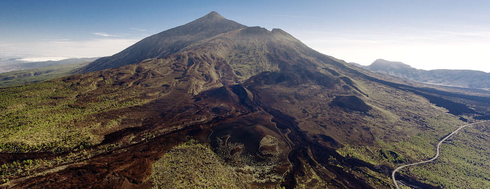
Despite the fact that the Island was created by volcanic activity and rose from nothing out of the depths of the ocean, the only documentary records of its eruptions date from after the Conquest. The Cañadas del Teide National Park is the best place to discover Tenerife's legendary volcanoes, housing the undisputed star: Mount Teide. The Ucanca lookout point is a privileged spot for views over Pico Viejo, rising 3,135 m (10,285 ft) above sea level, with a crater measuring 800 m (2,624 ft) in diameter. Visitors journeying down along the north-west ridge will also discover the eruptions of Boca Cangrejo, Trevejo and Chinyero, as well as the stunning views towards the islands of El Hierro and La Gomera.


