
Buenavista del Norte
Buenavista del Norte's lighthouse marks the end of Tenerife, looking out over its spectacular crystal clear waters. Buenavista stands on the north-westerly-most point of the Island. The municipality's town houses plenty of beautiful and highly valuable buildings. Its landscapes and countryside are among the most remote and untouched on Tenerife.
The municipality of Buenavista del Norte, which was founded in the 16th century and is a proud preserver of its traditions, lies on the north-west edge of Tenerife. It is without doubt one of the most scenic parts of the Island and a wonderful place to live, as its more than 5,000 inhabitants will vouch for.
The town has plenty of unquestionable appeal, with its charming streets, its coast dotted with bays and its environmentally-friendly leisure activities.
80% of the municipality's land belongs to different protected nature areas. One of the most noteworthy is Teno Country Park, a natural monument covering some 7,500 hectares (18,500 acres) of stunning rural and marine landscapes, with spectacular mountains and ravines.
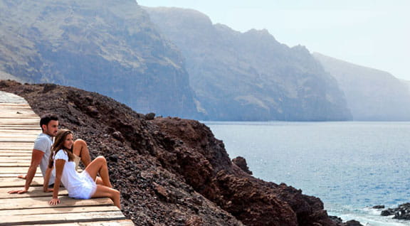
The Los Gigantes Cliffs, standing 300 to 600 m (985 to 1,970 ft) tall, plunge straight into the sea beside the Masca ravine. Following this somewhat tortuous ravine inland you will come to the hamlet of Masca, one of the finest examples of rural architecture on Tenerife, which has been declared an Ethnographic Area.
The last significant occurrence in the history of Buenavista took place in 1996 when the Church of Nuestra Señora de los Remedios was destroyed by a huge fire, sending much of its artistic-historic heritage up in flames. The building has since been restored.
Buenavista del Norte has various routes you can take to explore the municipality's cultural and artistic heritage. A walk around its historic quarter takes just an hour and a half. It sets off from the San Francisco convent, leading walkers to discover such significant buildings as the chapel of San Sebastián or the House of Culture, ending at the Triana bridge after visiting the old washing place in the ravine. There are shorter cultural routes that trace the most characteristic features of the hamlets of El Palmar, Masca and Teno Alto. These walks combine historic and architectural sites with breathtaking views of the ravines and the coast of Buenavista del Norte.
Trails around the municipality
The magnificent countryside in Buenavista del Norte is crossed by various trails ranging from intermediate to low difficulty. The easiest walk takes roughly 45 minutes and covers about 1.5 km (0.9 miles) along a promenade that links the beach of Las Arenas to the beach of El Fraile. Another route named Las Cuevas Ravine - Teno Bajo, starts at Los Bailaderos and ends at the lighthouse on Punta de Teno after a 4.25 km (2.64 mile) walk. There is also another trail from Los Bailaderos that is only suitable for the most daring hikers. Although it is just 4 km (2.5 miles) long and the walk itself is not difficult, you may get dizzy if you are afraid of heights.
We answer to your frequently asked questions
Everything you need to know about Buenavista del Norte
What to see in Buenavista del Norte?
Among the main sights in Buenavista del Norte are:
- Historic centre, featuring traditional Canarian architecture and a very local atmosphere.
- Plaza de Los Remedios and the Church of Nuestra Señora de los Remedios, central points of the town.
- Buenavista Lighthouse, a modern and distinctive structure set in a spectacular volcanic landscape, perfect for enjoying views of the Atlantic Ocean and the cliffs.
- Landscapes of the Teno Massif, with views over ravines, cliffs, and rural areas.
- Coastal surroundings, where the volcanic scenery meets the sea.
What to do in Buenavista del Norte?
Buenavista del Norte is an ideal destination for enjoying nature at a relaxed pace. You can take walks around the historic centre, enjoy outdoor activities, and visit natural areas. A must-do activity is walking the coastal trail leading to the Buenavista Lighthouse, a perfect spot for photography and watching the sunset. It is also a good starting point for exploring the Teno Massif and other corners of north-west Tenerife.
Are there hiking trails in Buenavista del Norte?
Yes, Buenavista del Norte has trails that traverse traditional paths, rural areas, and natural spaces in the Teno Massif. These routes allow visitors to discover unspoilt landscapes, ravines, and ocean views, making them especially attractive for hiking enthusiasts and photographers.
How to get to Buenavista del Norte?
- By car: From Santa Cruz de Tenerife or the northern part of the island, you can reach Buenavista del Norte via the TF-5 to Icod de los Vinos, then continue along local roads. Access is straightforward, although the final section is more winding.
- By public transport: TITSA bus lines connect Buenavista del Norte with other northern municipalities, though journeys are longer than from the central areas of the island.
How far is Buenavista del Norte from Tenerife North and South airports?
- The distance from Tenerife North Airport to Buenavista del Norte is approximately 60 kilometres, with a car journey taking around 1 hour 15 minutes, depending on traffic and the chosen route.
- From Tenerife South Airport, the distance is greater, around 85 kilometres, with an estimated driving time of 1 hour 30 minutes, mainly via the TF-1 and TF-5 before continuing on local roads to the north-west of the island.
What is the weather like in Buenavista del Norte?
The weather in Buenavista del Norte is mild throughout the year, with gentle temperatures and a higher presence of clouds compared to southern Tenerife. Winters are moderate and summers pleasant, favouring outdoor activities and visits to the natural surroundings.
Which beaches are near Buenavista del Norte?
The beaches in Buenavista del Norte are of volcanic origin and stand out for their natural character. The best known is Playa de las Arenas, with black sand and regular waves. There are also natural pools and swimming areas frequented by locals, always recommended in calm sea conditions.
Where to eat in Buenavista del Norte?
In Buenavista del Norte, you can find restaurants and bars serving Canarian cuisine, many using local products and traditional recipes. Fresh fish, hearty dishes, and simple options for a meal after a walk or hike are commonly available.
Where to stay in Buenavista del Norte?
Accommodation options in Buenavista del Norte include rural lodgings, small hotels, and restored traditional houses. They are a good choice for those seeking peace, contact with nature, and a more authentic experience in north-west Tenerife.
When is the Buenavista del Norte romería?
The romería in Buenavista del Norte is usually held in May, as part of the town’s patron saint festivities. It is one of the most popular celebrations, featuring decorated carts, traditional costumes, folk music, and local products, taking place through the streets of the historic centre in a lively, participatory atmosphere. The exact date may vary each year, so it is advisable to check in advance if you wish to coincide with the celebration.