
“Casa de las Miquelas” pottery centre
During the 18th and 19th century, pottery was the main industry in the municipality. This centre, located in a revamped traditional house, is named…
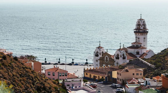
Candelaria has a special air about it. This town is a symbol of the entire archipelago's sincere religious devotion. Its solemn basilica surrounded by impressive bronze statues of the Guanche kings houses a figure of the Virgen de la Candelaria, the patron saint of the Canary Islands, who is more fondly known as "La Morenita" (the Brunette). This is a meeting point where thousands of pilgrims converge every 15 August after having set out at the crack of dawn – if not sooner! – on a long walk across the Island to worship their saint.
Located in the south-east of Tenerife, the municipality of Candelaria spans 49.18 km2 (18.9 sq. miles) and has approximately 26,134 inhabitants. This town is one of the Island's religious focal points ever since the figure of the Patron Saint of the Canary Islands, the Virgen de Candelaria, was found by the aborigines in 1392. Every year, thousands of devotees flock to the Nuestra Señora de la Candelaria basilica, despite the fact that the original figure of the Saint was lost in a wild storm during the 19th century. The merging of Guanche and Spanish culture that followed the conquest of Tenerife is plain to see in the monuments of Candelaria, especially the bronze statues of the Guanche kings that stand proudly in Plaza de la Patrona de Canarias.
Hidden caves and natural beaches define the surroundings of Candelaria, full of corners with that fishing village charm, and a lovely promenade along the sea front. Its restaurants serve traditional recipes made of fresh fish and lovely desserts to keep your energy levels topped up, ready to explore the town's streets and most emblematic sights. Candelaria also has a great network of trails across the hillside.
Routes around the municipality
The centre of Candelaria is a lovely town to amble through and take in its wealth of artistic heritage. Plaza de la Patrona de Canarias is an excellent starting point from which to head out on an excursion to the caves of Achbinico and Los Camellos, or to simply sit in while admiring the sculptures of the Guanche kings as the waves break in the ocean behind them. The basilica of Nuestra Señora de la Candelaria and the Dominican Monastery are compulsory stops on your quest to understand the municipality's cultural importance. On your way to the neighbourhood of Santa Ana, near the Casa Cabildo (the old town hall), you can visit the Church of Santa Ana and the pottery centre of “Casa de las Miquelas”. To round off your tour of Candelaria's historic quarter, take a walk along the pedestrianised street of Obispo Pérez Cáceres and the promenade with its variety of cafés and restaurants overlooking the sea.
Trails in the municipality
The steep slopes of the Chacorche ravine, its gulleys and well make water the key element all along the trail, which is intermediate-low in difficulty. The footpath starts at Plaza de Ajoreña in Igueste de Candelaria and follows Calle Los Revolcadores up to a dirt track. Tabaibas make up most of the greenery until the trail fully enters into Corona Forestal Natural Park, where Canarian pines take over. At the end of the trail, after some 4.5 km (2.8 miles), you will come to the Chacorche gulley. The trail of La Mesa is suitable for beginners and affords wonderful panoramic views over the Valley of Güímar. The trail starts at the La Florida ravine, in the town of Araya, and one of the sights hikers will find on their way is Casa de la Mesa, a 19th century building.
The trail of Lomo El Centeno, for intermediate level hikers, reveals some of Tenerife's most typical species of flora and fauna. This round trip leads all the way to the Protected Nature Area of Las Lagunetas and covers 5.7 km (3.5 miles). Another round trip, though on an intermediate-high difficulty trail, is Los Brezos, which passes through Corona Forest Natural Park and reveals some highly significant elements of the area's agricultural activity outside the park. For those who are less accustomed to hiking or who simply wish to enjoy the coastal landscape of Candelaria, the Samarines trail is a perfect option. Running parallel to the cliff, the trail crosses black sandy beaches and passes a series of blowholes. It sets off from the old town hall of Candelaria and comes to the cliff of Risco de la Magdalena and the Samarines ravine. The walk then turns back along the same trail for roughly 2 km (1.2 miles) to Plaza de la Patrona de Canarias. Other trails you can take are El Rincón, which is just 1.4 km (0.8 miles) long, and El Moralito, both of which are very popular among the hikers who visit Candelaria.
Candelaria is located on the south-east coast of Tenerife, between Santa Cruz de Tenerife and the Güímar Valley. It is one of the municipalities with the greatest historical and symbolic value on the island, known for its religious tradition, seafront promenade, and close relationship with the sea.
Candelaria is famous for being the main pilgrimage centre of the Canary Islands and for hosting the Basilica of Our Lady of Candelaria, the patron saint of the archipelago. The town is also known for its local atmosphere, volcanic sand beaches, and seafront promenade, which combine tradition, culture, and everyday life by the ocean.
Candelaria is best explored on foot and combines heritage, tradition, and the sea. The main points of interest are concentrated between the historic centre and the coastline:
Candelaria is easy to reach thanks to its good road connections:
The climate in Candelaria is mild and pleasant year-round. Temperatures typically range from 18 °C in winter to 26 °C in summer, with mostly sunny days. This weather allows visitors to enjoy the beaches and outdoor walks in any season.
Candelaria’s beaches have volcanic sand and a local atmosphere. Among the best known are:
These are urban beaches, well connected and suitable for swimming when the sea is calm.
Candelaria offers a wide range of dining options, with restaurants and bars specialising in Canarian cuisine, particularly along the seafront promenade. Fresh fish, traditional dishes, and local cuisine can be enjoyed in a relaxed setting with sea views.
In addition to the coastal area, Candelaria has routes through ravines and traditional paths into the interior of the municipality. These trails offer a more natural and less urban experience, with views of the valley and the south-east coast of Tenerife.
The most notable festival is the celebration of the Virgin of Candelaria, held in August and February, attracting thousands of pilgrims. During these celebrations, religious ceremonies, processions, cultural events, and popular activities take place, forming an essential part of the town’s identity.
The pilgrimage walk traditionally takes place at the beginning of August, coinciding with the festivals in honour of the Virgin of Candelaria, the patron saint of the Canary Islands. The peak moment is usually the night of 14–15 August, when thousands of people walk from different parts of Tenerife to the Basilica of Candelaria as part of the tradition and popular pilgrimage.
Accommodation in Candelaria includes hotels, apartments, and tourist lodgings, both in the town centre and in areas near the coast. It is a good base for those looking for a local environment with good connections to the rest of the island.