Casa de los Molinos
Only one flour mill in the municipality can still be visited. Located below ground level, it often goes unnoticed because of the urban development…
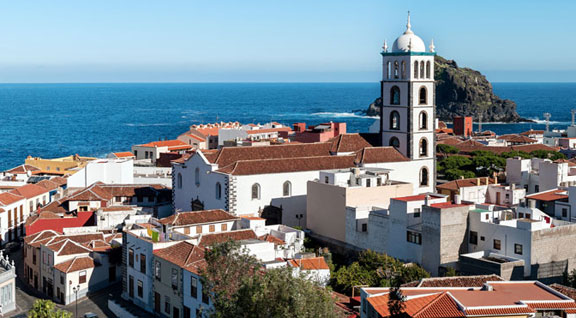
Its cobbled streets invite visitors to explore the heart of the town, its churches and its historic buildings. Garachico is a living legend: who said it's impossible to be reborn from the ashes? When the Trevejo volcano erupted in 1706 it destroyed almost the entire town, but what that meant was an opportunity to rebuild it even more beautiful and charming than before.
Garachico lies in the north-west of Tenerife in the region of Icod-Daute-Isla Baja, covering 29.28 km2 (11.3 sq miles). At least half of that area is covered with Canarian pine trees, volcanic scenery and an ancient cliff that separates the historic quarter from the hills. Garachico has a wealth of architectural heritage from the 16th and 17th century which has been kept in wonderful condition, leading it to be declared an Asset of Cultural Interest in 1994. It was also granted the status of "Villa" (which is roughly equivalent to the British status of Borough) and Port by King Alfonso XIII in 1916. On the coast of the municipality there are several vast estates with banana groves, whilst the farmland on the hillsides was mainly used to supply the families who farmed it. The town also has a recently built marina by the historic quarter, as well as a series of beaches made of pebbles and black sand, and various cliff faces. Special mention should be made of the natural swimming pools of El Caletón, one of the most popular bathing areas, as well as the impressive rock formation rising from the sea in front of them.
After the conquest of Tenerife, Garachico became the main fishing and trade port on the Island until it was destroyed by the volcanic eruption. This golden age drew many highly influential families to settle here, which is apparent from the wealthy layout of its streets and buildings.
A stroll around Garachico reveals its architectural heritage, culture and peaceful atmosphere. In the 16th and 17th century, Garachico was Tenerife's hub for trade and finance until the Trevejo volcano buried the old port under a river of lava. Despite the catastrophe, some of the buildings were unscathed and still remain exactly as they were. You can explore these old constructions together with the more modern buildings on a leisurely route through the municipality's historic quarter.
The walk sets off from the San Francisco monastery dating from 1526, which stands opposite the central Plaza de la Libertad. The route then continues towards Casa de Piedra (the Stone House), also known as Casa de los Condes de la Gomera. Although much of the building was destroyed by the eruption, the original Renaissance stone façade still stands. This is also the case for the Church of Santa Ana, as you will see further along your route. The church too had to be rebuilt after the lava left only its two stone façades standing. The next stop is Plaza Juan González de la Torre, which was the town centre in the 16th and 17th century. Opposite the square is a cosy little park inside which you will find Puerta de Tierra, the old gateway that once marked the boundary between the port and the city.
Heading on towards the coast, you will come to the castle of San Miguel, an Asset of Cultural Interest. The castle was built in 1575 and was hit by a terrible fire in the late 17th century, but it was then rebuilt decades later. Near the castle are a series of natural swimming pools known as El Caletón, which line the coast as the route goes on to Casa de los Marqueses de la Quinta Roja. This 16th century building has an inner patio surrounded by a wooden veranda, and it marks the end of a trail around Garachico's most historically relevant sites.
Approved trails in the municipality
From Garachico there is a trail with an intermediate-high level of difficulty that ends at the Chinyero volcano. The trail journeys up along the El Lance road to San Juan del Reparo through a spectacular landscape full of tongues of solid lava and comes to the recreational area of Arenas Negras. During this five-hour hike, you will see such natural wonders as the centenary pine of Cha Lorenza, the views of Mount Teide and the landscape from the lookout point over the southern side of the Chinyero volcano.
Garachico is located in the north-west of Tenerife, between the municipalities of Los Silos and Icod de los Vinos. It is one of the best-preserved historic towns on the island and stands out for its volcanic origin and traditional character by the sea.
Reaching Garachico is straightforward, as it is well connected to the northern road network. It lies about 61 km from Santa Cruz de Tenerife (45–55 minutes by car) and around 50 km from Tenerife North Airport (40–45 minutes).
Among the main attractions in Garachico are:
In addition to exploring the historic centre, visitors can enjoy natural spaces, walk along the coastline, swim in volcanic pools and learn about the local history shaped by the volcanic eruption that transformed the port in the 18th century.
Surfing in Garachico is possible at several points along its volcanic coastline, particularly in areas exposed to the northern swells. It is not a destination with large sandy beaches but rather natural reef breaks, so it is generally more suitable for experienced surfers and only when sea conditions are appropriate. On calmer days, bodyboarding and other wave-related activities are also common.
Yes, hiking around Garachico is a great way to explore the municipality and its natural surroundings, with routes that combine volcanic coastline, historic paths and midland landscapes:
These walks are generally relaxed routes, ideal for enjoying the landscape and combining hiking with a cultural visit to the town.
The town was partially buried by the 1706 Garachico volcanic eruption, which destroyed its former commercial port. This event changed the municipality's economic development but also created the volcanic landscape and natural pools that characterise the coastline today.
Yes, the coast of Garachico is known for its volcanic bathing areas:
These are not wide sandy beaches but natural volcanic spaces adapted for swimming when the sea is calm.
The weather in Garachico is mild throughout the year, generally cooler than in many areas of southern Tenerife. Typical seasonal conditions include:
This climate is very comfortable for walking and outdoor activities almost all year round.
In Garachico you will mainly find restaurants and bars serving traditional Canarian cuisine, many located in the historic centre, where dishes made with local ingredients are prepared. Fresh fish, papas arrugadas, meat dishes and homemade recipes are common, all served in a relaxed and welcoming atmosphere. In the surrounding areas there are also Guachinches, where homemade meals are served alongside locally produced wine, offering a dining experience closely linked to local traditions. Several establishments also have terraces overlooking the sea or the squares of the historic centre, allowing visitors to enjoy local gastronomy while exploring one of the most representative historic towns in northern Tenerife.
Garachico hosts several traditional festivals throughout the year, closely linked to its history and local traditions:
Accommodation in Garachico mainly consists of small-scale establishments such as boutique hotels, rural houses and tourist apartments, many located in the historic centre or close to the sea. It is a good option for travellers seeking a quieter atmosphere with strong heritage value and a slower pace.
Garachico was declared a Bien de Interés Cultural because of the historical and architectural value of its old town, one of the best preserved in Tenerife. It retains churches, convents, squares and stately houses from the 16th and 17th centuries linked to its period as one of the island's most important commercial ports. Its preservation after the 1706 eruption further reinforces its historical and cultural importance.
Yes, visiting Garachico with children is a very good option, as the town is calm and easy to explore on foot. Families can stroll through squares and streets with little traffic, walk along the coast and enjoy open spaces by the sea. The El Caletón Natural Pools are often one of the most attractive spots for families on calm sea days, while exploring the historic centre allows visitors to combine leisure and learning about the town's history in an enjoyable way.