
The Chapel of San Antonio Abad
This is one of Tenerife's oldest chapels, housing a figure of San Antonio which is believed to have been the first to reach the Island after the…
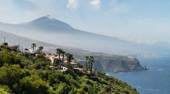
The view from La Matanza over the north side of the Island is quite simply spectacular. But there is more to the town than that – La Matanza contains a wealth of natural treasures and its history is closely linked to several of the most dramatic episodes in the conquest of Tenerife, making it worthy of a visit.
The municipality of La Matanza de Acentejo covers 14.1 km2 (5.45 sq miles) in north-eastern Tenerife. Its name means the Massacre of Acentejo because it was the scene of a great battle that took place during the conquest, when the aborigines defeated the Spaniards. The municipality borders with La Victoria de Acentejo, Candelaria and El Sauzal, and reaches its highest point in Lomo del Jugo at 1,589 m (5,213 ft) above sea level. The cliffs on the coast are populated with varied vegetation, from sea heath (Frankenia ericifolia), sea fennel (Astydamia latifolia), Rhamnus crenulata and Canarian St John's wort (Hypericum canariense), as well as Canary island spurges and tabaibas. By contrast, the mountains are covered in macronesian heathland and tree heath and two types of pine (Pinus canariensis and Pinus radiata). The municipality's hillsides have been altered significantly by man.
The municipality's history began in 1494 in the Acentejo ravine with the battle known as the Massacre of Acentejo, during which the Guanches defeated the conquistadors leveraging their territorial advantage under the guidance of their king, Mencey Bencomo de Taoro. Captain Alonso Fernández de Lugo had no choice but to fall back and abandon the invasion temporarily. After the conquest, the area that now houses the municipality of La Matanza was one of the most populated regions.
Today, the coast of La Matanza is sprinkled with residential villa estates and several wineries giving visitors the opportunity to sample the area's exquisite wines. On the way up into the mountains is the recreational area of La Vica, which is perfect for a picnic or a day out with friends and family.
La Matanza has a series of urban trails leading visitors around the municipality and revealing its landscapes, hidden corners, wine culture and gastronomy. The service road on the TF-5 motorway has been used to create a footpath along which there are resting areas and lookout points overlooking the sea, as well as parks with outdoor exercise equipment.
The area of Los Nateros has been equipped with two such exercise parks and marks the beginning of the trail of La Bandera, leading up into the Bandera mountain. There are plenty of other walking routes to take from this farmland area, with special mention to be made of the trail that sets off from the district of El Pirul along the San Cristóbal footpath.
Approved trails in the municipality
SL-TF 26 Los Nateros-La Vica-Los Nateros.
SL-TF-27 Los Nateros-Pino La Morra-Los Nateros.